
How Flood Risk Shapes Buying a Home in Chiang Mai
In our experience, flooding is the question buyers ask more quietly than smoke, often on a second viewing. The honest answer is that flood risk here is very local. Two houses a few hundred metres apart can have completely different histories, and a plot’s own record tells you far more than the district name on the listing.
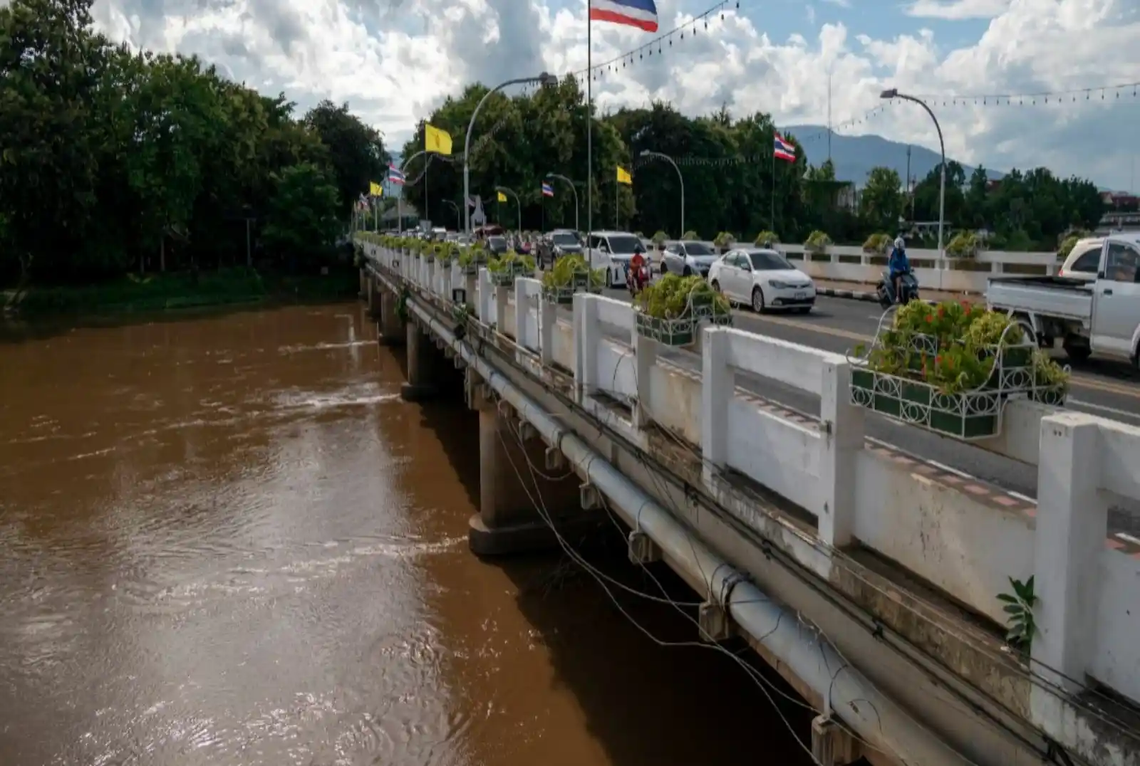
In the first week of October 2024, the Ping River rose above 5.2 metres at Nawarat Bridge. Water stood more than a metre deep around the Night Bazaar and Chang Klan Road, Kawila Hospital closed its doors, and trains stopped running into the city. A few kilometres away, on higher streets, daily life carried on. For anyone buying here, that contrast is the whole story: flood risk in Chiang Mai is real, it is seasonal, and it is intensely local. After burning season, it is the other seasonal question our clients ask us about most, so here is what we look at before anyone signs.
Chiang Mai has two flood risks. The Ping River overflows through the city centre and low-lying downstream areas in major years, most recently October 2024. Mountain run-off causes faster local floods near Doi Suthep, Mae Rim and Hang Dong. Check any plot against both risks.
Why Does Chiang Mai Flood, and How Bad Has It Been?
Chiang Mai sits in a valley where the Ping River and dozens of mountain streams collect monsoon rain, and the highest risk runs from late August to mid October. Major river floods reached the city in 2005, 2011, 2022 and 2024, with 2024 the worst in about 50 years.
The number to watch is the river gauge at Nawarat Bridge, known as station P.1. The city’s levees are built to handle a reading of roughly 4.2 metres there, according to Nation Thailand. Above that, water starts spilling into low streets on both banks. In 2024 the river crossed that line twice: 4.93 metres in the early hours of 25 September, as The Thaiger reported, then above 5.2 metres in early October, with a reported peak of around 5.3 metres.
| Year | Reported peak level | What flooded |
|---|---|---|
| 2005 | About 4.9 mReported level, historical records | Riverside areas of the city centre |
| 2011 | About 4.95 mReported level, historical records | Riverside areas of the city centre |
| 2022 | About 4.75 mReported level, historical records | River broke the old barrier at Pa Daet, damaging homes and farmland |
| September 2024 | 4.93 m | Night Bazaar and Chang Klan Road |
| October 2024 | Above 5.2 mReported peak around 5.3 m, the highest in about 50 years | Night Bazaar and Chang Klan under more than a metre of water, Warorot and Ton Lamyai markets, Kawila Hospital, the railway station; Pa Daet, Saraphi, Hang Dong and San Pa Tong downstream |
Sources: Nation Thailand, 5 October 2024; Nation Thailand, 7 October 2024; Thai PBS World; Chiang Rai Times (2022). Levels before 2024 come from historical records rather than a single official release, so treat them as approximate.
The rains start around May, but the dangerous weeks come late in the season. By September the ground is saturated and upstream reservoirs are full, so a tropical storm crossing the north has nowhere to drain. Every serious Chiang Mai flood event we found in 2024 and 2025 fell between 23 September and 7 October.
Which Parts of Chiang Mai Are Most Exposed to Flooding?
It depends on which of two risks a property faces. Ping River overflows hit the riverside city centre and low-lying land downstream, while mountain run-off hits villages and suburbs at the foot of Doi Suthep, Doi Pui and the western hills.
| Risk | How it arrives | Where it was reported, 2024 to 2025 | Warning |
|---|---|---|---|
| Ping River overflow | Slowly, over hours or days, as the river rises | City centre around the Night Bazaar, Chang Klan and Warorot; downstream in Pa Daet, Saraphi, Hang Dong and San Pa Tong | GoodRiver levels are published and forecast |
| Mountain run-off and local streams | Fast, often overnight after heavy rain | Mae Rim villages in Mae Raem, Rim Nuea and Rim Tai; Pa Ha and Chiang Mai University below Doi Suthep; Hang Dong along the Mae Tha Chang; Mae Rim and San Pa Tong again in 2025 | LittleOften minutes to hours; phone alerts help |
This table shows where flooding was reported, not a ranking of districts. Being in a named district does not mean a property flooded, and a street can behave very differently from the district around it. Use it to decide which questions to ask, not which areas to rule out.
If you are looking in these areas, our Hang Dong guide and Mae Rim guide cover the neighbourhoods themselves. This post is only about water.
Is a Hillside or Suburban Home Automatically Safe From Floods?
No. Distance from the Ping protects you from river floods, but not from run-off. In 2024 some of the most repeated flooding happened well away from the river, at the foot of the mountains.
On 3 October 2024, Nation Thailand reported that villages in Mae Rim’s Mae Raem, Rim Nuea and Rim Tai sub-districts had flooded for the fourth time in a month, fed by run-off from Doi Suthep and Doi Pui. A week earlier, on 27 September, a torrent came down Doi Suthep overnight, flooding the Pa Ha community, overflowing Ang Kaew reservoir into Chiang Mai University and swamping the Ton Phayom intersection, according to Thai PBS World. In Hang Dong, the Mae Tha Chang river broke its bank on 23 September 2024, putting the Ban Chang Kham community under more than 50 centimetres of water and closing Hang Dong Road (Nation Thailand). None of these were caused by the Ping breaking its banks there.
It happened again in September 2025, when flash floods and overflowing rivers, including the Mae Sa and the Khan, reached 45 villages across Mae Chaem, Mae Rim, Galyani Vadhana and San Pa Tong. In San Pa Tong alone, 701 households in 18 villages were affected, according to Chiang Mai Citylife.
This is the part buyers most often miss. The view, the garden and the cooler air are the reasons people look at foothill homes, and they are good reasons. But the slopes, streams and green gullies that make these areas attractive are the same features that channel water when rain falls hard. That does not rule them out. It means asking different questions than you would in town.
On a foothill or streamside plot, walk the boundary before you look at the kitchen. Notice where the land slopes, where the nearest stream or drainage channel runs, and whether the house sits above or below the lane. A home raised on its plot, with water free to run around it, is very different from one sitting in a dip.
How Do You Check a Property’s Flood History Before Buying?
Ask people who were there in 2011 and 2024, look for physical signs on the building, and check the public flood maps. No single check is enough on its own, but together they give you a clear picture within a day or two.
| Check | How | What it tells you |
|---|---|---|
| Ask the neighbours | Knock on two or three doors, or ask the village headman or the estate office, about 2011 and 2024 | Whether water came in, how deep, and for how long |
| Look for water lines | Check lower walls, gate posts, boundary walls and garage doors for a faint horizontal stain, or fresh paint only on the lowest band | Past water height, or a recent cover-up |
| Compare levels | Stand in the lane: is the floor above the road, the neighbours and the nearest canal? | Whether water drains away from the house or towards it |
| Ask about drainage | Ask the estate’s juristic person or the developer how the estate drains and whether pumps are installed | How the estate coped in 2024 |
| Check the public maps | GISTDA flood maps show satellite-mapped flooding in past years; ThaiWater shows live river levels | Whether the area appeared in past flood footprints |
| Ask the seller in writing | Ask directly whether the property has ever flooded, and keep the answer | A record, if you learn otherwise later |
A Chanote title deed proves who owns the land. It says nothing about whether the land floods, so treat flood checks as their own step, alongside the title checks in our guide to avoiding property scams. If you are building rather than buying, raise the floor level and the electrical sockets and ask your builder about land fill; our guide to finding a trusted builder covers the vetting.
If your timing allows, view in September or October. We would rather a client sees a street after a week of rain than on a dry February morning, because the lane tells you more than the listing photos ever will.
Are Chiang Mai Condos Safe From Flooding?
Units above the ground floor rarely take water, but the building around them can. In riverside buildings the weak points are basement parking, lifts, water pumps and electrical rooms, where flood damage can leave residents without power or lifts until repairs are done.
Condo buildings close to the river around Chang Klan and the Night Bazaar sat inside the 2024 flood zone. Before buying in a riverside building, ask the juristic person four things: whether water entered the building in 2024, where the pump and electrical rooms sit, what the building’s flood plan is, and whether any repairs were paid from the sinking fund. The answers tell you as much about how the building is run as about the river. Our guide to buying a condo in Chiang Mai covers the rest of the purchase.
What Is Being Done to Reduce Flooding in Chiang Mai?
Flood defences are being raised and warnings are getting faster, but nothing announced so far removes the risk. Treat new works as a reduction, not a guarantee.
The Royal Irrigation Department’s Region 1 office has raised a 303-metre flood wall downstream of the Wang Tan floodgate in Pa Daet from 3.70 to 5.20 metres, designed for river flows of up to 800 cubic metres per second. It protects Pa Daet and Saraphi, where the 2022 flood broke through the old barrier, and was due for completion in mid-2026, according to Chiang Mai Citylife. The Department of Disaster Prevention and Mitigation now also sends location-based flood alerts straight to mobile phones, and Chiang Mai was placed on flash-flood watch as recently as 20 August 2026 (Nation Thailand). For live river levels, the ThaiWater app is the simplest tool we know.
The Pa Daet wall is a physical engineering work, and the phone alerts are running now. Neither means a 2024-scale flood cannot happen again. Do not rely on a seller volunteering a property’s flood history — ask directly.
Does Home Insurance in Thailand Cover Flood Damage?
Often, but not always. Many home policies include flood, yet some cap or exclude it for addresses with a flood history, so confirm flood cover is written into the policy before you rely on it.
There is also a new safety net. In September 2026 the Cabinet approved a national disaster insurance scheme worth 15.5 billion baht a year, covering around 30 million homes against floods, windstorms and earthquakes. It pays up to 100,000 baht per home per incident, with an initial flood payment of 10,000 baht within 15 days, and cover runs from 1 October 2026 to 1 October 2027. The Department of Disaster Prevention and Mitigation runs it with the Office of Insurance Commission (Nation Thailand; Insurance Journal).
Two things to keep in mind. This is a government scheme, not a law, and the current cover lasts one year, so renewal is not guaranteed. And eligibility is tied to homes recognised under civil registration law, so check whether your home qualifies rather than assuming it does. Even where it applies, 100,000 baht is emergency help, not a replacement for a proper home policy. One simple habit helps with any claim: photograph the property in detail on the day you take the keys, so you have a baseline if you ever need it.
People Also Ask
Which areas of Chiang Mai flood the most?
The worst Ping River flooding hits the riverside city centre around the Night Bazaar, Chang Klan and Warorot, plus low-lying Pa Daet, Saraphi and parts of Hang Dong and San Pa Tong downstream. Foothill villages below Doi Suthep and Doi Pui face faster run-off floods instead.
How can I check if a property in Chiang Mai has flooded before?
Ask neighbours and the village office about 2011 and 2024, look for water lines on walls and gate posts, and compare the plot level with the road. GISTDA publishes satellite flood maps showing where water reached in past years.
Does home insurance in Thailand cover flood damage?
Many policies include flood, but some cap or exclude it for addresses with a flood history, so confirm it in writing. A government disaster scheme approved in September 2026 pays up to 100,000 baht per eligible registered home per incident.
Thinking About a Home That Stays Dry in the Rainy Season?
Tell us which street or estate you are considering and we will share what we know about it before you view, then help you ask the right questions when you do. You can reach me on WhatsApp at +66 64 338 9597 or on LINE at chiangmai-properties.
Disclaimer: We are real estate professionals sharing local market observations and public flood reports. This is not engineering, insurance or legal advice. For a specific property, check official sources such as GISTDA, the Royal Irrigation Department and the Department of Disaster Prevention and Mitigation, ask your insurer or the Office of Insurance Commission about cover, and consider a qualified surveyor.



.webp)
